Showing posts with label GPS. Show all posts
Showing posts with label GPS. Show all posts
Monday, January 28, 2008
Location Tagger
Nokia Betalabs has released another great beta application called Location Tagger. It allows you to automatically tag your location data to your pictures. GPS coordinates are saved to the EXIF header of the JPEG file. This application is intended to give you a sneak preview of features that are planned to be integrated into your phone. Looking forward to future firmware updates with these features implemented.

Wednesday, December 26, 2007
Top 5 free applications for N95 - updated list
I first made the list of top 5 free applications for N95 in July. A lot has happened since then and I think it's time to update the list.
TOP 5 FREE APPLICATIONS FOR N95
TOP 5 FREE APPLICATIONS FOR N95
- RotateMe v2.0 - This is a beta version but the final version should be released soon. RotateMe jumps straight to first place on my list. It's a great tool that allows you to switch from landscape to portrait mode automatically by tilting the phone.
- Google Mobile Maps - The latest version of Google Maps supports the internal GPS receiver. It also shows your an estimation of your location even if you don't have a GPS signal.
- SportsTracker - New version of Sports Tracker was launched in November and Nokia also launched Nokia Sports Tracker Beta Web Service.
- Widsets - Widsets is not really a single application but a platform for mini-applications called widgets. Widgets bring you content from your favorite websites to your phone.
- Opera Mini - Great web browser if you don't have an unlimited data plan - Opera Mini helps you save money by reducing the amount of data transferred
Sunday, October 14, 2007
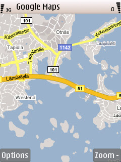
Finally - Google Maps with GPS for N95
This is great news for all of us N95 users. The latest version of Google Mobile Maps now supports the internal GPS of N95. To see your location on the map, go to menu and select "Show my location".
To install point your phone's browser to www.google.com/gmm and follow the instructions.

To install point your phone's browser to www.google.com/gmm and follow the instructions.


Friday, August 17, 2007
Windsurfing with N95
Windsurfer Finian Maynard currently holds the speed record for sailing vessels. The official speed records are set on 500 meter course. During the last couple of years it has become very popular to use a GPS device while windsurfing. Using GPS you are not limited to a fixed course but can measure speed the whole time you are windsurfing. There's even a web site gps-speedsurfing.com, where you can submit your results.
I decided to test if N95 and Sports Tracker would be of any use while windsurfing. I didn't have any fancy waterproof pack for my phone so I just used two resealable plastic bags - I used two to be safe. First I thought of using just the N95 but for good GPS reception you need to slide it open and that's not very practical so I put a bluetooth GPS in another plastic bag.

Everything was set up and I was ready to go. I sailed for about half an hour and came back to shore to check the log. It worked great. Below is a Google Earth screenshot of my sailing session in Mellsten (local beach here in Espoo, Finland). The fastest speed I achieved was 46.7 km/h. Not too bad for a first attempt and considering my not so speed optimized gear (freestyle board and a wave sail). Sport Tracker allows you to export the log as GPX, XML, CSV and Google Earth KML-format. Click the image to download the track log as a Google Earth kml-file.

I decided to test if N95 and Sports Tracker would be of any use while windsurfing. I didn't have any fancy waterproof pack for my phone so I just used two resealable plastic bags - I used two to be safe. First I thought of using just the N95 but for good GPS reception you need to slide it open and that's not very practical so I put a bluetooth GPS in another plastic bag.

Everything was set up and I was ready to go. I sailed for about half an hour and came back to shore to check the log. It worked great. Below is a Google Earth screenshot of my sailing session in Mellsten (local beach here in Espoo, Finland). The fastest speed I achieved was 46.7 km/h. Not too bad for a first attempt and considering my not so speed optimized gear (freestyle board and a wave sail). Sport Tracker allows you to export the log as GPX, XML, CSV and Google Earth KML-format. Click the image to download the track log as a Google Earth kml-file.
Monday, July 9, 2007
New firmware and GPS
I've now tested the new firmware (12.0.0.013) for a couple of days. I've always said that having a phone with integrated GPS is great but I've also criticized how slow the GPS acquired satelite lock. The new firmware with Assisted GPS support is a huge improvement.
I have been testing the GPS quite a lot during the last two days. Lock to satelites is acquired very quickly, even inside a car. When starting the Maps while driving a car, it takes on average less than 30 seconds to lock to satellites. In similar conditions with the previous firmware version it usually took more than 10 minutes. What an improvement! No more critisism about long waiting times before the GPS is operational.
Before the firmware was officialy released there were rumors that it would also include a new version of Maps application. The version of new Maps is not included in this FW update. I guess we'll have to wait a bit longer for the new Maps.
I have been testing the GPS quite a lot during the last two days. Lock to satelites is acquired very quickly, even inside a car. When starting the Maps while driving a car, it takes on average less than 30 seconds to lock to satellites. In similar conditions with the previous firmware version it usually took more than 10 minutes. What an improvement! No more critisism about long waiting times before the GPS is operational.
Before the firmware was officialy released there were rumors that it would also include a new version of Maps application. The version of new Maps is not included in this FW update. I guess we'll have to wait a bit longer for the new Maps.
Thursday, May 24, 2007
GPS and maps
It's a great feature to have a built-in GPS receiver. Having used many SIRFstar III equipped GPS devices, I guess I've been spoiled. SIRFstar III is known for its fast Time to First Fix (TTFF) and its ability to acquire and maintain a signal lock even indoors. When you start the Maps application in N95, it takes quite a long time before it acquires a signal lock.
What's really great about N95 is that you can download all the maps you need for free. Just go to smart2go.com and download the Nokia Maploader. Use maploader to download maps and store them on a microSD memory card. That way your phone doesn't need to use the network to download maps saving your data charges. It also saver battery life.
You can search for an address or enter the starting point and end point and the N95 will find a route. If you plan to use it as a car navigator with turn-by-turn instructions, you have to pay for a subscription service. Except for the turn-by-turn navigation, there are no other subscription fees. The Maps application is easy to use. You can pan, zoom in/out and change between 2D and 3D views.
The points of interest (POI) database that comes with the maps is very good and you can search for things nearby. The POIs are grouped into dozens of categories and in the settings, you can choose which categories are shown on the map.
In conclusion, the N95 doesn't quite offer the performance of dedicated GPS navigators. However, it's great to have a GPS device with you at all times. Having said that, I'll still keep my Garmin Nüvi.
What's really great about N95 is that you can download all the maps you need for free. Just go to smart2go.com and download the Nokia Maploader. Use maploader to download maps and store them on a microSD memory card. That way your phone doesn't need to use the network to download maps saving your data charges. It also saver battery life.
You can search for an address or enter the starting point and end point and the N95 will find a route. If you plan to use it as a car navigator with turn-by-turn instructions, you have to pay for a subscription service. Except for the turn-by-turn navigation, there are no other subscription fees. The Maps application is easy to use. You can pan, zoom in/out and change between 2D and 3D views.
The points of interest (POI) database that comes with the maps is very good and you can search for things nearby. The POIs are grouped into dozens of categories and in the settings, you can choose which categories are shown on the map.
In conclusion, the N95 doesn't quite offer the performance of dedicated GPS navigators. However, it's great to have a GPS device with you at all times. Having said that, I'll still keep my Garmin Nüvi.
Subscribe to:
Posts (Atom)

