Typing http://www.google.com/gmm on the N95 browser allowed me to download and install the application. No problems whatsoever. The application appeared in "Applications"-menu and has a nice sized "Google Maps" icon. You can move around, zoom in and out and most importantly switch between map and satellite view. The satellite view was what I had been waiting for. A fast WLAN connection would be optimal for heavy use but even with 3G connection the maps and images loaded fast enough. Below are two screenshots (map and satellite image) from the same location in London, UK.


5 comments:
does GM use the on board GPS of the N95? I'm thinking that as i've bought the N95 that I own the GPS and i'd rather not have to pay for GPS software to use MY GPS on the N95.
Tried Google Maps on my N95 looked ok but out of date maps and sat pix by about 3 to 5 years :(
Also battery got very hot using the app for a short while.
Unfortunately the current version of Google Mobile Maps doesn't have support for GPS.
I wouldn't be surprised to see GPS support in future versions of Google Maps.
Is there a need to download gmaps if the Nokia already has its own maps?
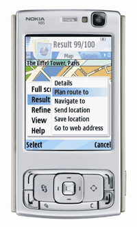
Nokia's own Maps application is really great and normally it's all you need. But in addition to normal map view, Google Maps gives you the possibility to view satellite images as well.
Post a Comment